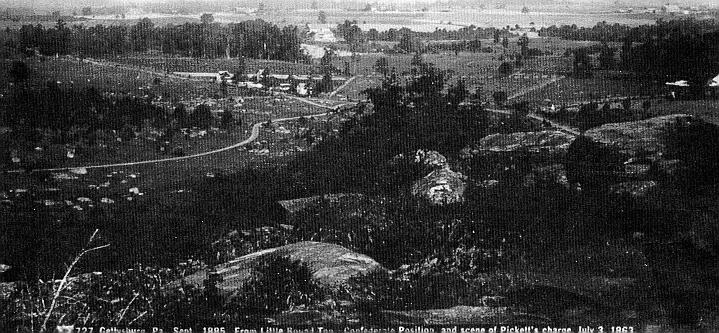
![]() "The error was in charging
over so broad a space"
"The error was in charging
over so broad a space"![]()
![]() "The error was in charging
over so broad a space"
"The error was in charging
over so broad a space"![]()
ABOUT THE AUTHORS
![]()
David Shultz is the author of "Double Cannister at Ten Yards: The Federal Artillery and the Repulse of Pickett's Charge." He is currently finishing work on a comprehensive study of the Federal artillery at Gettysburg.
Richard Rollins is the editor of Pickett's Charge! Eyewitness Accounts and the author of The Damned Red Flags of the Rebellion" : The Confederate Battle Flag at Gettysburg. He would like to thank Harold Bernstein and George Otter for their help. He is currently working on another book on Pickett's Charge. Both reside in Southern California and are members of the Civil War Round Table of Long Beach.
They would like to thank Bill Baker, Brian Ipjian, Jess Ogdon, Harold Bernstein, George Otton, Charles Hathaway and Scott Hartwig for their help.
As Capt. Henry Owen
of the 18th Virginia Infantry marched with Brig. Gen. Richard B. Garnetts
brigade toward the stone wall on July 3, 1863, he noticed a large body
of Federal troops moving from Cemetery Ridge toward the right flank of
Maj. Gen. George E. Picketts division. He recalled that he measured the
distance with my eye as accurately as the best surveyors compass and chain
ever constructed could do, and concluded that they were 400 yards away.
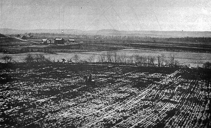
Many other participants in Picketts Charge guessed the distances that the Confederates crossed and over which the Federal troops fired. Some of the participants estimates were made during and shortly after the battle, others were recalled from memory long after the war. Thus incorrect and contradictory estimates of distances were numerous. The authors have measured most of the distances they guessed at, as well as many others in an effort to better understand the charge and its repulse.
For example, Maj. Charles Peyton, the only regimental commander in
Picketts division who survived to write a post-battle report, guessed that
the distance between Seminary Ridge and Cemetery Ridge was 800 to 1,000
yards.
The distances were equally elusive for the men on the left of the Confederate
attack. In Maj. Gen. Isaac R. Trimbles division, Maj. Joseph Englehard
estimated that his men marched about a mile.
To General Trimble, it seemed that the distance between the lines was
crucial to victory or defeat. He estimated that his men were: exposed at
every step to a most destructive fire for a mile. This distance broke down
the men and [because they were] exhausted & [their] ranks [were] thinned,
they only reached the enemys line in small numbers and were repulsedThe
error was in charging over so broad a space. Had the troops marched at
night to 1/4 mile of the works & charged vigorously by day break we
must have carried the lines on the enemys left.
Other distances also seemed debatable. Brig. Gen. Joseph R. Davis, commanding
a brigade in General Pettigrews division, believed that the right of the
division, owing to the conformation of the ridge on which the enemy was
posted, [had] a shorter distance [than the divisions left] to pass over
to reach [the Federal] first line of defense. . . . Davis also stated that
the Emmitsburg Road was three-fourths of a mile from the Federal lines.
On top of Cemetery Hill, Maj. Thomas Osborn, in charge of the Eleventh Corps Artillery, estimated that the Pettigrew-Trimble line was nearly a mile distant when they became:
...the sole object of fire of all the guns which could be made to bear
upon them. The effects of this fire could very soon be seen. At first the
distance was so great that only solid shot from the brass guns and percussion
shells from the rifled guns could be effectively used. The artillerymen
endeavored to roll the solid shot through the ranks and explode the percussion
shells in front of their lines. . . . As the lines advanced, both the rifled
and smooth bore guns used time shells upon the advancing lines and the
killing and wounding was proportionately more severe.
The Federal artillery played a crucial part in the repulse of Picketts
Charge, one that has often been overlooked.
After spending a good deal of time trying to ascertain more closely
the distance involved in the Confederate charge and the Federal defense,
we decided that the only way to develop an acceptable degree of accuracy
was to measure as many lines as we could. Over three years, and five visits,
we did just that. We started out with a surveyors rope but found it unsatisfactory,
so we remeasured those few lengths with a surveyors wheel and then measured
the rest of the distances.
The accompanying maps show the lines, and the following explanations describe in words as specifically as possible what each line stands for:
Map 1
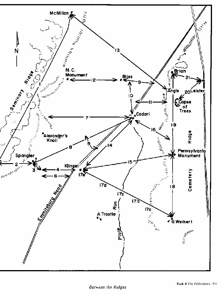
Between The Ridges
1. South edge of McMillan House driveway to gate for Spangler House on Confederate Avenue: 6,301 feet.
2. South post of Spangler gate to south end of rock fence around Spanglers Woods: 1,350 feet.
3. End of rock fence to intersection of four fences at bottom of swale: 475 feet.
4. Intersection of four fences at bottom of swale directly east of south end of Spanglers Woods to fence on west side of Emmitsburg Road at north end of Klingel House: 1,515 feet.
5. Alexanders battalion. From right wheel of right gun at Emmitsburg Road to Spangler Farm lane: 238 feet. To left gun: 526 feet.
6. From a spot 200 feet south of intersection of four fences at bottom of swale directly east of south end of Spanglers Woods to fence on west side of Emmitsburg Road: 1,434 feet.
7. Southwest corner of Point of Woods platform to fence on west of Emmitsburg Road across from southwest corner of Codori Barn: 3,327 feet.
8. Southeast corner of Spangler Barn to southwest corner of Codori Barn: 2,642 Feet.
9. West side of fence on west side of Emmitsburg Road to bottom of swale west of Bliss Farm: 1,072 feet.
10. Fence west of Emmitsburg Road across from Codori House to Bliss House marker: 1,356 feet.
11. Copse of Trees to ridge of first swale west of Emmitsburg Road: 1,002 feet.
12. Fence west of Bliss House to west side of iron fence around North Carolina monument: 1,678 feet.
13. Angle to McMillan House: 4,000 feet.
14. Codori Barn to Klingel House: 2,168 feet.
15. Pennsylvania Monument to Klingel House: 3,620 feet.
16. The marker for Daniels 9th Michigan Light Battery to the Codori Barn: 1,600 feet.
17A. The marker for Ames 1st New York Artillery, Company G to low ground (ravine): 1,237 feet.
17B. To the knoll: 1,706 feet.
17C. To Plum Run: 2,030 feet.
17D. To rise: 2,390 feet.
17E. To Klingel Barn: 3,800 feet.
18. McGilverys line from the right flank of Daniels battery to the George Weikert Farm: 2,281 feet.
19. Second Corps line, from the Pennsylvania Monument to the Brian Barn: 3,000 feet.
20. Leister House to Copse of Trees: 1,350 feet.
21. Leister House to Brian Barn: 1,030 feet.
Map 2
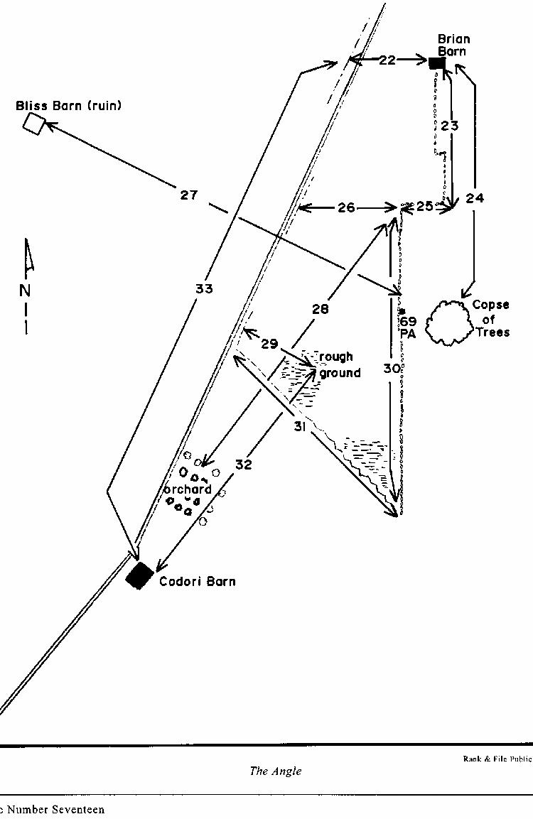
The Angle
22. Northwest corner of the Brian Barn to the west fence at Emmitsburg Road: 420 feet.
23. Hays division wall, following the wall running from southeast corner of Brian Barn (including the jog), to inner angle: 775 feet.
24. Brian Barn to Copse of Trees: 1,085 feet.
25. Inner Angle to outer Angle: 248 feet.
26. Angle to fence east of Emmitsburg Road: 585 feet.
27. Right flank of 69th Pennsylvania to Bliss Barn: 1,188 feet.
28. Angle to Codori Orchard: 806 feet.
29. Fence east of Emmitsburg Road to rough ground: 394 feet.
30. Harrows (Gibbons) division line, Angle to end of rock wall south of Copse of Trees: 840 feet.
31. Fence from Emmitsburg Road to end of rock wall on Cemetery Ridge: 998 feet.
32. Codori Barn to rough ground: 882 feet.
33. Codori Barn to Emmitsburg Road west of Brian Barn: 1,386 feet.
Distances Not On Maps
A. Fence on west side of Emmitsburg Road across from southwest corner of Codori Barn to southwest corner of Codori Barn: 97 feet.
B. Emmitsburg Road, just north of Codori Farm: from east side of fence west of Emmitsburg Road to white line marking the west edge of the road: 15 feet. From there to white line marking east edge: 23 feet. From there to fence on east side: 14 feet.
C. Klingel House to Angle: 3,796 feet.
Map 3
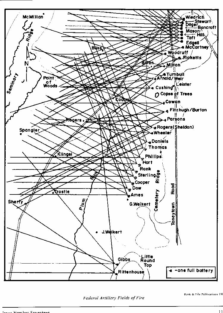
Federal Artillery Fields of Fire
Each batterys field of fire is represented by three lines on the map, one each for the left, right and center of their probable fields of fire. The length of the lines on the map correspond to the distances that the individual batteries could reach. Since a battery normally had four or six guns, the map should have 12 or 18 lines per battery, but it would make the map virtually unreadable.
The effective range of each type of weapon is calculated at ground level with a five degree elevation and a maximum powder load. Effective range is gained as the elevation is increased. Since the Federal batteries were generally higher than their targets, their range was slightly longer than shown here, so these ranges are slightly conservative. We have omitted Lt. Sylvanus T. Ruggs and Lt. David H. Kinzies batteries because we are unsure of the time they joined the fray.
12-pounder Howitzer: 1,800 yards.
12-pounder Napoleon: 1,800 yards.
3-inch Ordnance Rifle: 2,100 yards.
10-pounder Parrott Rifle: 2,400 yards.
14-pounder James Rifle: 2,800 yards.
20-pounder Parrott Rifle: 3,000 yards.
Map 4
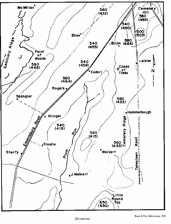
Elevations
Over the years the Gettysburg battlefield has been mapped many times. We compared several maps and found discrepancies between all of them. We assume that the latest, the United States Geological Survey, originally done in 1944 but revised in 1951 and again in 1973, is the most accurate. John Bachelders map of 1876 (based on those of the Warren team) is probably the most frequently cited, so we have mapped the field and placed the comparative elevations of those two. It is interesting to note that the modern figures are generally consistently about 100 feet higher than the previous map, probably due to the use of more sophisticated equipment.
The important point, however, is not the elevation, but the difference
between the elevations of the Federal artillery sites and the places where
the Confederate infantry moved. From the Confederate lines, intervening
undulations in the land often hid the Federal guns, especially those on
McGilverys line. We believe that it is possible that the Confederate high
command did not know that McGilverys guns were posted along the southern
extension of Cemetery Ridge, or that the gunners would have an easy target
when the right flank of Picketts division marched across their front, just
350 yards away. Using the modern Pennsylvania Monument, which marks the
right flank of McGilverys line, as a marker, one can walk along the woods
on Seminary Ridge and rarely get a glance at McGilverys line. The base
of the monument is visible only from a few spots along Seminary Ridge between
the Peach Orchard and the Point of Woods, the line along which Lee and
Longstreet travelled while planning the maneuver. McGilverys line only
comes fully into view when one is at the crest of the ridge just west of
the Emmitsburg Road, and from the Peach Orchard. This would explain why
Confederate reports of the planning of the charge mention only the guns
on Little Round Top.
Additional factors complicate matters. Our measurements reflect the lay of the land in 1994 to 1996. The topography may have changed since 1863. During World War I a training camp for tank commanders was established just south of town between the Emmitsburg Road and Seminary Ridge. As part of this, a U.S. officers swimming pool was built just west of the stone wall south of the Copse of Trees, now covered by a patch of briars over some rocks. Camp Colt by name, it was established in 1917 and later dismantled in 1919. During World War II a prisoner of war camp was constructed along the Emmitsburg Road contiguous to the south side of the lot that is now the site of the Home Sweet Home Motel. A temporary facility, this camp only existed for seven months and did not change the landscape apart from buried water lines and a set of latrines. Finally, when the building now housing the Cyclorama was constructed, the topography of Cemetery Ridge where it stands was altered. An inquiry to the National Park discovered that no records exist of the amount of land moved during construction.
Conclusions
Many different interpretations and conclusions can be drawn from the figures given here, but just a few will be cited as examples of how this information can be used. The distance traveled by Kempers right flank (lines 8 + 11) was about 3,998 feet, or 1,290 yards. The distance covered by the left flank of the Pettigrew-Trimble line (line 13) was almost identical, about 4,000 feet. The length of the attacking line as it prepared for the charge, (lines 1 + 2 + 3) was 8,126 feet, or 2,708 yards, well over one mile (1,760 yards). The length of the Federal Second Corps defensive position (line 19) was 3,000 feet, or 1,000 yards. The length of the Federal line defended by Harrows and Hays divisions of the Second Corps, where the charge reached the wall (23 + 30), was 1,615 feet, or 538 yards. Thus the Confederate line at the point of attack was reduced to just 20% of its original length.
Line 17 is one of the most interesting. It represents the field of fire of Lt. Nelson Ames Company G, 1st New York Artillery, on the far left flank of McGilverys line. From the military crest of Cemetery Ridge they looked west, only to see a knoll some 1,706 feet (568 yards) in front of them (17B) partially blocking their view. When Kempers brigade came over the rise west of the Emmitsburg Road 3,800 feet (1,266 yards) away (17E), their right flank brushed the Klingel Farm and they came within sight and range of Ames guns. As they moved up the Plum Run valley, Kempers men disappeared, hidden behind the knoll. They reappeared as they passed the knoll, and were within range almost until they reached the Codori Farm.
The distance between the center of the Federal line and the fence on the east side of the Emmitsburg Road, (line 26) where the Confederates received the first infantry volley, was 585 feet, or 195 yards, well within musket range, but not an easy shot. At 200 yards, the Civil War rifle-musket was not particularly accurate. This may help explain how those who survived the first volley were so lucky.
The distance at which Lt. Tully McCrea began his slaughter of Confederate
troops, and the distance that the left flank of the Pettigrew-Trimble line
had to endure it (11 + 22), was 1,776 feet, or 592 yards. As the left flank
of the charge came up to the muzzles of McCreas guns, they did indeed present
a splendid target. If W. H. Swallow, a Confederate engineer who measured
and walked the route after the war, was correct, and the Confederates moved
at the quickstep rate of 85 yards per minute, it would have taken the left
flank just seven minutes to cross the field under the fire of the Federal
guns, not counting the time it took to climb the fences at the Emmitsburg
Road. Yet during that time, if McCreas two brass 12-pounder Napoleons got
off two rounds of canister per minute, as he claimed,
they sent at least 14 rounds of canister at the oncoming Rebels.