|
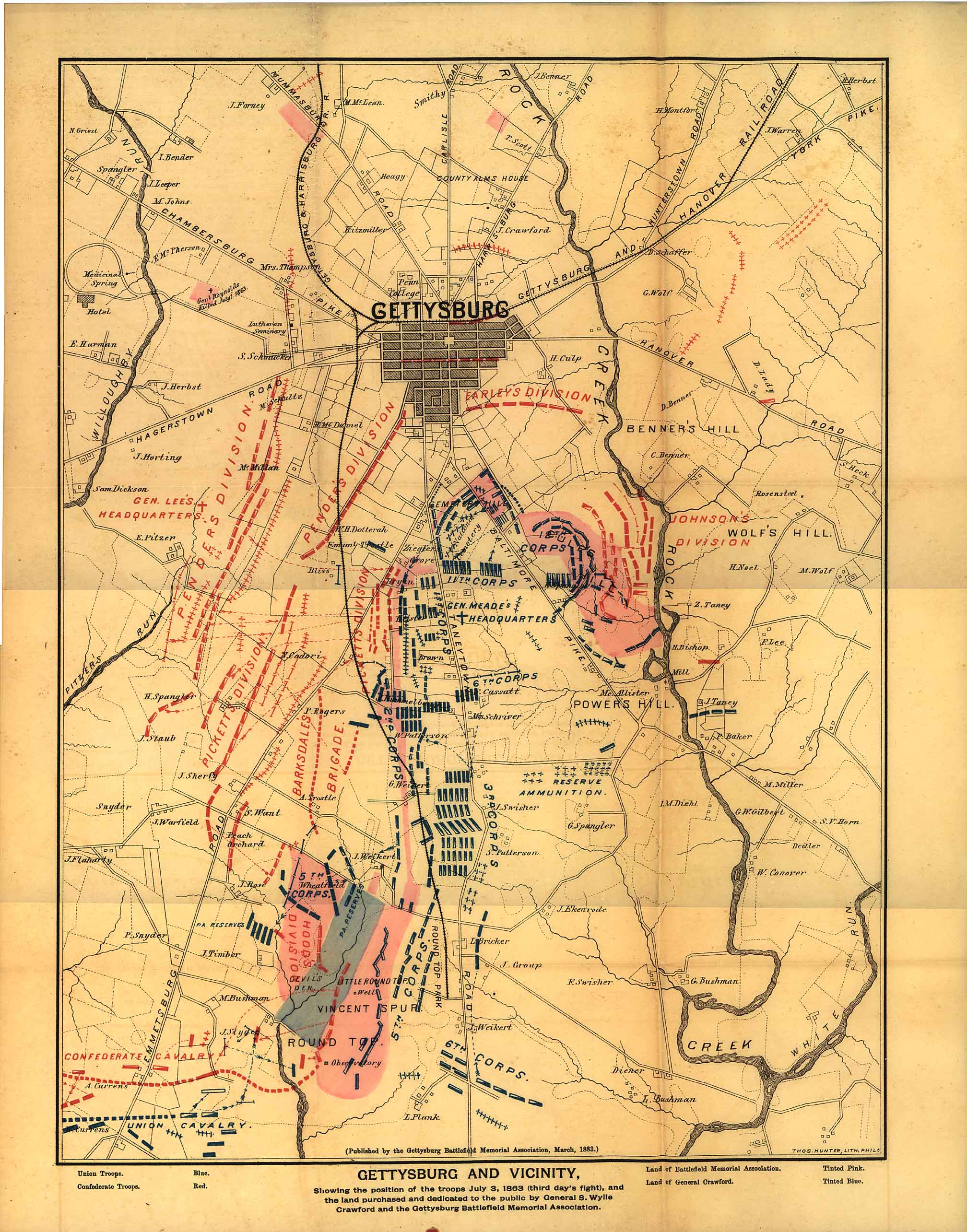
(Click on map to view map) |
|
Gettysburg Memorial Association Map - 1883 |
|
(Click on map to view map) |
|
At a meeting of the board of the Gettysburg Battlefield Memorial Association on July 27, 1882, it was resolved: "That a committee of three be appointed to ascertain the cost of a map of the Battlefield of Gettysburg, with the lands owned by the Memorial Association indicated in color. The Vice President [Robert G. McCreary] appointed Gen. Wagner, N. G. Wilson and John M. Krauth the committee. " [1] On December 29, 1882: "Mr. McCreary submitted a report from the Executive Committee. After consideration some alterations were made and on motion of Dr. Horner Resolved, However, it appears that the map committee was having some difficulty in getting the map ready for publication. Two weeks later, on January 9, 1883, General Louis Wagner sent the following letter to John B. Bachelder [member of GBMA and Superintendent of Tablets and Legends]: "Dear Sir Can your guide book map be used to accompany the last annual report of the Battlefield Association, the property owned by them to be assigned by stencilled colors? Red for Association and Blue for Crawford's land. If yes: what would be the cost of an edition of 1000-2500 or 5000 on good but thin map paper. Give me figures by return mail also time required as the maps are needed for the Legislatures now in session. Yours very truly For whatever reason, the idea of using the Bachelder tour book map was soon abandoned. General Wagner corresponds with parties in New York and Boston seeking a suitable publisher for the map. Philadelphia January 20th, 1883 Dear Sir After considerable delay caused by correspondence with parties in New York and Boston I am able to submit the following figures of Thomas Hunter of this City for a map such as we need 18x14 inches or four times the size of our report: for engraving three stones, blue, black and red $50.00 Printing three colors & stenciling This map will show the town, all the roads and streams, hills and mountains, names of principal owners of land, our property in pink, Crawford's blue, position of rebel troops (3rd days fight) red, and Union troops blue, also names of Division and Corps Commanders on both sides. Shall I order 2500 or 5000? The latter strikes me as the proper number. Please advise me as promptly as possible General Wagner contracts with Thomas Hunter of Philadelphia Pa. to print the map, though vice-president McCreary, in a letter to Bachelder, frets at the delay in its completion. Gettysburg, Pa. Dear Sir Yours just recd. It was a happy thought and I am very much pleased to see that you have done just what was needed, and what may enable us to pull through. The delay on our part is caused by Gen. Wagner's inability to get our map ready. You may know that at his suggestion the board agreed to make a map of the battlefield so as to show what we own of it. This to be used in connection with our efforts after appropriations. I am almost out of patience at the delay in getting it ready and fear it will throw us too late to accomplish much this winter. I now hope your action may save us in your state. Wagner is chairman of the sub-committee and you and I are the other members. I am in expectation daily of hearing that he is ready to move. Yours very truly, The map is finally printed by Hunter in March of 1883 as indicated by the inscription along the bottom border of the map. By July 2, 1883, with the difficulties experienced by the GBMA in obtaining their battlefield map successfully overcome, the map is highlighted in the Report of the Executive Committee on that date: "Report of the Executive Committee of the Gettysburg Battle-Field Memorial Association (Adopted July 2, 1883)" [6] the Association reports that: "For the purpose of giving correct information to the Association and to the general public, we have published a neat Map of the battle-field, showing the positions of the armies on the third day of the battle, and showing the land owned by and under the care of the Association. A large number of these, in connection with a pamphlet containing the Acts of incorporation, and Reports upon the organization and work of the Association, have been circulated, and we think, with good effect." |
|
|
|
At a meeting of the Association on Resolved, That the officers be instructed to prepare and have printed a circular setting forth concisely the origin, aims and purposes of the Gettysburg Battlefield Memorial association with statement of what has already been accomplished and what work remains to be done. |
|
Resolved, That Gen. Wagner be authorized to have printed a new edition of the map of the field with such changes as have been made since the first edition was published." It is the new (1884) edition of the 1883 map that appears here in the map room. The map was published along with a pamphlet entitled: It is significant to note the small amount of land held by the GBMA on the 1st day battlefield as of the publication of the 1884 edition of the map. The purchase of "Sixty feet square, on Barlow's Knoll, the point occupied by the 17th Conn. Volunteers" had been negotiated by May of 1884 as had an agreement with Judge Wills to sell a small amount of land for the placement of monuments for the Massachusetts regiments (12th and 13th Mass). [7] The paltry holdings on the first days field would be addressed shortly with the issuance of a second edition of the map in 1885. Footnotes: Terry Moyer June 23, 2000 |
|
