|
(Click on map to view map) Download Hi-Res map (1.9Mb) |
|
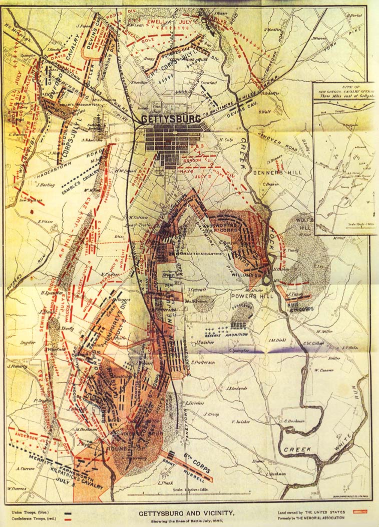
Gettysburg Memorial Association Map - 1895 |
|
(Click on map to view map) Download Hi-Res map (1.9Mb) |
|
GETTYSBURG A HISTORY OF THE Gettysburg Battle-field Memorial Association WITH AN ACCOUNT OF THE BATTLE GIVING MOVEMENTS, POSITIONS, AND LOSSES OF THE COMMANDS ENGAGED BY JOHN M. VANDERSLICE PUBLISHED BY THE MEMORIAL ASSOCIATIONPHILADELPHIA 1897 |
CONTENTS. PAGE Map Frontispiece. Introduction 9 Gettysburg 15 Losses in the Twelve Greatest Battles of the War 17 The Town and Field 19 The Ten Roads leading into the Town 21 The Advance of the Army 22 The Cavalry Fight at Hanover 27 Forces Engaged and the States represented in the Battle 29 FIRST DAY'S BATTLE. Approach of the Confederates 33 Encountered by Buford's Cavalry 34 |
|
At the final meeting of the Gettysburg Battlefield Memorial Association "Major-General Daniel E. Sickles, U.S.A., offered a resolution, which was unanimously adopted, authorizing… the publication of two hundred and fifty copies of the history of the Memorial Association, and making an appropriation for the expense thereof." [1]The history of the Memorial Association was written by John M Vanderslice, a director of the Association. It was printed as a limited edition by J. B. Lippincott of Philadelphia in 1897. The frontispiece to this rare volume, was the map of the battlefield, presented here by the Gettysburg Discussion Group. The 1895 map is of course an evolved version of the 1886 edition, which has been updated to show the holdings of the Association as of 1895; the year this property was transferred to the care of the U.S. Government. The map is a testimonial to the effectiveness of this organization of private citizens. During the 30 years of its existence the GBMA was able to acquire and to transfer to the United States government "six hundred acres of land which had been acquired by the Association, upon which seventeen miles of avenues had been constructed, giving access to the most interesting points of the battle-field, and to consign to the care and protection of the general government the three hundred and twenty monuments which had been erected upon the field by the several States and by regimental associations." [2]As this map illustrates, the association had acquired substantial new holdings. Especially notable are acquisitions in the southern portion of the field. Parcels have been added in the area of the Round Tops, the South Cavalry field, the Peach Orchard and the 6th Corp positions of Neill avenue. The holdings of General Crawford have also been absorbed by the association. A representation of the East Cavalry battlefield has been added to this edition of the map, in accordance with the resolution of board of the GBMA on Aug. 11th, 1885. All of the GBMA maps measure approximately 14 x 18 inches. The 1895 map is from the collection of Terry Moyer. Footnotes:
Terry Moyer June 18, 2000 |
|